Glaciers and Glaciation
GLACIERS AND GLACIATION
James L. Dyson
At the present time portions of the Earth's land surface, with a total area equal to about twice that of the United States, are covered with ice. This ice is comprised entirely of glaciers ranging in size from the colossal ice cap of Antarctica, which submerges an entire continent nearly as large as the United States and Europe combined, down to small mountain glaciers only a few acres in extent. If this ice were to melt the resulting water would cause sea level all over the world to rise more than 50 feet, inundating coastal regions in which a large part of the population is concentrated.
Although most of the largest glaciers are to be found in Greenland, the Antarctic, Alaska, and the Yukon, there are many thousands of them scattered all over the world in lofty mountain ranges. Some of the longest valley glaciers occur in the Himalaya and other high ranges north of India. Glaciers occur in all latitudes and on every continent except Australia. They are even present along the Equator on high volcanic peaks of Africa and in the rugged Andes of South America. At least 300, covering a total area of about 200 square miles, are present in six of our western states.
Origin of Glaciers
Why do glaciers occur at so many places? To find the answer we must examine such things as snowfall and elevation.
The ice of which every glacier is composed was at one time snow. Wherever each winter's accumulation of snow is greater than that which disappears by melting and evaporation during the following summer we can expect to find glaciers. Year after year this excess snow will continue to accumulate until deep enough to be compacted into ice. Ice thus formed cannot pile up indefinitely at the same place, but will, because of the weight of newly added ice and snow, flow outward from the source. Thus a glacier, moving ice derived from snow, is born.
Glaciers owe their existence principally to heavy annual snowfalls or low average temperature, or to both of these. In some localities, notably the Arctic and Antarctic regions and the Pacific Coast region of North America, a large amount of each winter's snow is not dissipated during the ensuing summer and remains where it falls to build up glaciers. Elsewhere, particularly within the Rockies and the Sierra Nevada, snow if it remained where it fell would not accumulate sufficiently to give rise to glaciers. Thus the masses of ice present in such places are the result of drifting snow. Practically all Rocky Mountain and Sierra Nevada glaciers lie on the east side of mountain crests where snow, blown from the west side by prevailing westerly winds accumulates in enormous drifts, frequently several hundred feet deep, and sometimes far below the mountain summits. Despite the disappearance of much of this snow during the warm days of summer, that which remains eventually becomes ice.
Excessive cold, therefore, is not essential to the formation of such glaciers. The main requirement is a winter snow accumulation so large that some of it will survive the summer, to be covered by more snow during the succeeding winter.
Motion of Glaciers
As long as it is fed by snow, the ice will continue to flow from the place of its origin to the point where motion is no longer able to overcome melting. Here the glacier must end and become merely a stream of water.
The movement, due mainly to gravity and the weight of overlying snow and ice, is similar to, but slower than, that which takes place in a fluid of extreme viscosity. All ice below a depth of about 100 feet moves in this manner. Ice near and at the surface is brittle, as evidenced by the crevasses visible on every glacier, and rides on top of the plastic ice beneath.
One of the world's largest glaciers moves nearly 100 feet a day. Most, however, move at a much slower rate. The large Muir Glacier in Alaska moves about seven feet per day. The largest glaciers in the Swiss Alps move about a foot per day. Movement of glaciers in Glacier National Park seldom exceeds an inch a day. At this rate ice within many of the latter requires as much as 200 years to make the trip from source to terminus. Meanwhile, each succeeding year's accumulation of snow has changed to ice and started out on a similar journey. This process keeps the glaciers continuously alive, and renews their "bodies" once in about every 200 years.
Glaciers of the United States
Glaciers occur only in the States of Montana, Wyoming, Colorado, Washington, Oregon, and California. The total number probably exceeds 300.
The largest glaciers in the United States are on the slopes of Mt. Rainier in the State of Washington. Several of these glaciers are four to six miles in length. The best known is Nisqually because of its accessibility, although one or two others exceed it in size.
Throughout the Cascade Mountains are a dozen or more other volcanic peaks which bear glaciers. Most noteworthy of these peaks are Mounts Adams, Baker, St. Helens, and Glacier Peak in Washington; Mounts Hood and Jefferson in Oregon, and Mount Shasta in California.
The Olympic Mountains in the extreme western part of Washington contain a group of glaciers, most of which are small. This group, as numerous as those within Glacier National Park, lie within the boundaries of Olympic National Park.
In the High Sierra of California there are about 50 very small glaciers, several of which, situated not far from Mt. Whitney, are the southernmost in the United States.
Remaining glaciers of the United States are confined to the Rocky Mountains and are scattered through the principal ranges between the Canadian boundary and Southern Colorado. In Montana, other than Glacier National Park, there are two glaciers in the Flathead Range immediately south of the Park; others are found in the Swan and Mission Ranges, and just north of Yellowstone National Park in the Beartooth Range is the Grasshopper Glacier and possibly other smaller ice bodies.
In Wyoming there are seven glaciers in the Tetons and several in the Bighorns and Absarokas. The Dinwoody Glaciers, numbering 10 or 12, in the Wind River Range are the largest in the Rockies south of the Canadian boundary.
The remaining Rocky Mountain glaciers are confined to Colorado, where most are in and near Rocky Mountain National Park. Two, in the Sangre de Cristo Range south of Pike's peak are the southernmost in the Rockies.
Glaciers of Glacier National Park
Within the boundaries of Glacier National Park there are 60 to 80 glaciers, of which only one has a surface area greater than one-half square mile, and not more than seven others exceed one-fourth square mile in area.
All these bodies of ice lie on east- or north-facing slopes at elevations between 6500 and 9000 feet, in all cases well below the regional snow-line. Thus they are alimentated almost entirely by wind-drifted snow.
Sperry is the largest glacier in the Park, and with the possible exception of one or more of the Dinwoody glaciers in Wyoming's Wind River Range, is the largest in the Rocky Mountains south of the Canadian boundary. Its surface area in 1946 was somewhat more than 330 acres.
The second largest glacier in the Park is Grinnell with a surface area of 280 acres. Both Sperry and Grinnell have probable maximum thicknesses of 400 or 500 feet.
Other important Park glaciers, although much smaller than the first two mentioned, are Chaney, Sexton, Jackson, Blackfoot, and Ahern. Several others approach some of these in size, but because of isolated locations they are seldom seen.
Most or all of these glaciers probably have been in existence for about 4,000 years. For several thousand years prior to the origin of these "modern" glaciers the climate of the Glacier Park region was somewhat drier and warmer than at present; thus there were no glaciers in the mountains during that period. And the existing glaciers obviously are not remnants of the large glaciers which were present during the Ice Age which terminated approximately 12,000 years ago.
Although the glaciers have been in existence for about 4,000 years, none contains ice older than 200 or 300 years, because of the processes of dissipation and renewal mentioned above.
Recession of Park Glaciers
Since the beginning of the present century all glaciers in the Park have been shrinking rapidly in response to a slight change in climate, probably involving both a temperature rise and a decrease in annual snowfall.
Determination of this shrinkage has been carried on by various methods since 1931, and is reported annually by the Park Service to the Committee on Glaciers of the American Geophysical Union. For the first several years the work consisted only of a determination of the distance the ice front of each of several glaciers withdrew annually. Such measurements were generally made at one point only, and thus were of comparatively little value. More recently several of the glaciers have been mapped on a scale of 1:2400; and two of them, Sperry and Grinnell, have been mapped twice at intervals of eight and nine years, respectively. Such re-mapping has enabled the volume shrinkage of the entire glaciers to be determined.
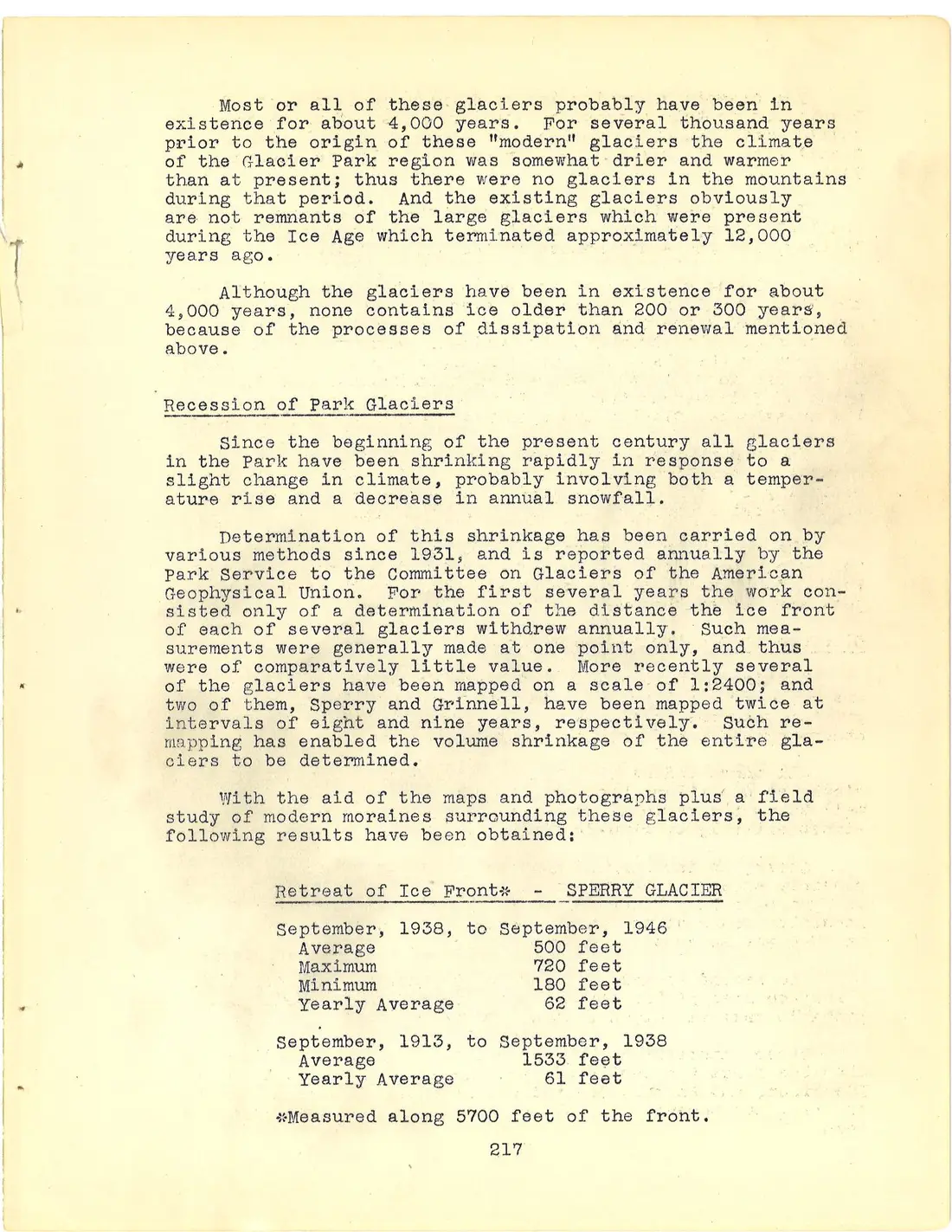
With the aid of the maps and photographs plus a field study of modern moraines surrounding these glaciers, the following results have been obtained:
Retreat of Ice Front* - SPERRY GLACIER
September, 1938, to September, 1946
Average 500 feet
Maximum 720 feet
Minimum 180 feet
Yearly Average 62 feet
September, 1913, to September, 1938
Average 1533 feet
Yearly Average 61 feet
*Measured along 5700 feet of the front.
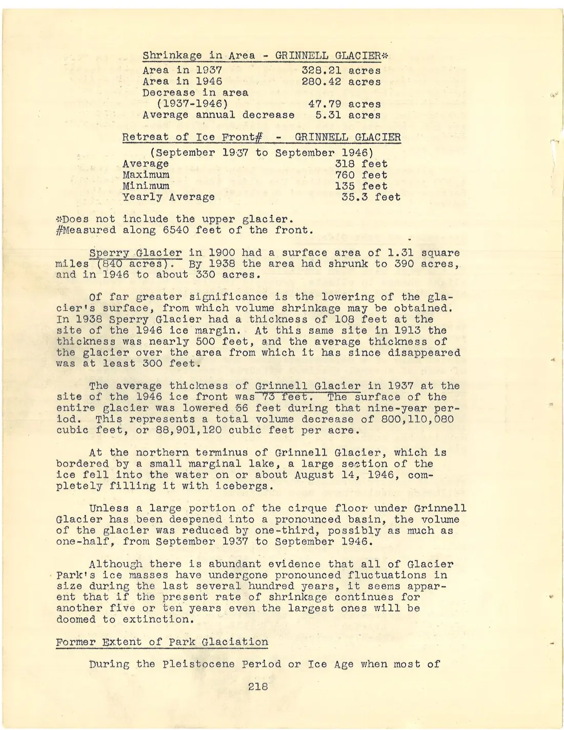
Shrinkage in Area - GRINNELL GLACIER*
Area in 1937 328.21 acres
Area in 1946 280.42 acres
Decrease in area (1937-1946) 47.79 acres
Average annual decrease 5.31 acres
Retreat of Ice Front# - GRINNELL GLACIER
(September 1937 to September 1946)
Average 318 feet
Maximum 760 feet
Minimum 135 feet
Yearly Average 35.3 feet
*Does not include the upper glacier.
#Measured along 6540 feet of the front.
Sperry Glacier in 1900 had a surface area of 1.31 square miles (840 acres). By 1938 the area had shrunk to 390 acres, and in 1946 to about 330 acres.
Of far greater significance is the lowering of the glacier's surface, from which volume shrinkage may be obtained. In 1938 Sperry Glacier had a thickness of 108 feet at the site of the 1946 ice margin. At this same site in 1913 the thickness was nearly 500 feet, and the average thickness of the glacier over the area from which it has since disappeared was at least 300 feet.
The average thickness of Grinnell Glacier in 1937 at the site of the 1946 ice front was 73 feet. The surface of the entire glacier was lowered 56 feet during that nine-year period. This represents a total volume decrease of 800,110,080 cubic feet, or 88,901,120 cubic feet per acre.
At the northern terminus of Grinnell Glacier, which is bordered by a small marginal lake, a large section of the ice fell into the water on or about August 14, 1946, completely filling it with icebergs.
Unless a large portion of the cirque floor under Grinnell Glacier has been deepened into a pronounced basin, the volume of the glacier was reduced by one-third, possibly as much as one-half, from September 1937 to September 1946.
Although there is abundant evidence that all of Glacier Park's ice masses have undergone pronounced fluctuations in size during the last several hundred years, it seems apparent that if the present rate of shrinkage continues for another five or ten years even the largest ones will be doomed to extinction.
Former Extent of Park Glaciation
During the Pleistocene Period or Ice Age when most of Canada and a large portion of the northern United States were covered by an extensive ice sheet or continental glacier, all the valleys of Glacier National Park were filled with valley glaciers. These originated in the higher parts of the Lewis and Livingston Ranges. On the east side of the Lewis Range they moved out onto the plains. From the Livingston Range and the west side of the Lewis Range they moved into the wide Flathead Valley.
The great Two Medicine Glacier, with its source in the head of the Two Medicine and tributary valleys, after reaching the plains spread out into a big lobe (piedmont glacier) eventually attaining a distance of about 40 miles from the eastern front of the mountains. The stream of ice emerging onto the plains from the St. Mary valley also extended many miles out from the mountain front. In the major valleys these glaciers attained thicknesses of 2000 or more feet.
At least twice these glaciers advanced down the park valleys, and at least twice they melted away and disappeared.
Evidence of these two distinct glacial advances is yielded by the deposits which they have left. On the east side of the park the lower courses of the major valleys and the adjoining ridges are covered with deposits of till in the form of a heterogeneous mixture of clay and various sized boulders. The debris deposited by the latest stage of glaciation, the Wisconsin, is fresh in appearance and contains fragments of all park rocks. The earlier stage, possibly of Kansan or Nebraskan Age, is represented by a much more weathered till. It contains many fragments of diorite, which is a rock resistant to weathering, and almost no fragments of limestone, so common in the newest moraine. The only localities where this older till occurs are the crests of the ridges which run eastward from the mountains out onto the plains. On top of Two Medicine Ridge along and just above the highway, fragments of this material have been cemented together into a comparatively hard tillite. Lower down on the slopes the older moraine cannot be found as it is covered by that of the Wisconsin glacier which was less extensive and did not over-ride the ridge crests as did the earlier glaciers. The older till is also found on the top of Milk River Ridge, as the glacier from the Cutbank Valley (Wisconsin Stage) did not attain the crest, although it did spill northward through the gap in the ridge (the highway now goes through this low place) for a distance of three miles into the Milk River Valley.
Following the maximum advance of the Wisconsin glaciers, they slowly receded or shrank until about 8,000 years ago when all glacial ice probably entirely disappeared from the mountains. Following this there was a warm dry period during which no glaciers were present. Then about 4,000 years ago the present small glaciers were born.
Park Features Resulting from Glaciation
A glacier is an extremely powerful agent of erosion, capable of profoundly altering the landscape over which it passes.
Glaciers erode mainly by two processes, plucking and abrasion. The first is most active near the head of a glacier, but may take place anywhere throughout its course; abrasion or scouring is effective underneath most sections of the glacier, particularly where the ice moves in a well-defined channel.
In plucking, the glacier actually quarries out masses of rock, incorporates them within itself, and carries them along. This is accomplished mainly by water which trickles into crevices and freezes around blocks of rock causing them to be pulled out by the glacier, and also by the weight of the glacier squeezing ice into the cracks in the rock. As the glacier moves forward these blocks of rock are dragged or carried along with it. Usually a large crevasse, the bergschrund, develops in the ice at the head of the glacier. The bergschrund of most glaciers in the park consists of an opening, usually 10 or 15 feet wide at the top and as much as 50 feet deep between the head of the glacier and the mountain wall. On Sperry Glacier, however, it is more typical of that found on larger valley glaciers and is a conspicuous crevasse separating the firm area (where the snow is compacted into ice) on top of Gunsight Mountain from the glacier proper below. It is at this site that plucking is most dominant because water enters by day and freezes in the rock crevices at night. This quarrying headward and downward finally results in the formation of a steep-sided basin called a cirque or less commonly a glacial amphitheatre. Because the cirque is the first place that ice forms and the place from which it disappears last, it is subjected to glacial erosion longer than any other part of the valley. Thus its floor is frequently plucked out to a comparatively great depth so that a body of water known as a cirque lake forms after the glacier disappears. Iceberg Lake is one of the best examples in the park, although Gunsight, Ellen Wilson, Avalanche, Ptarmigan, Hidden, and Cracker Lakes are good examples. Of the cirques commonly seen in the Park, those of Iceberg, Hidden, Avalanche, and Cracker Lakes are possibly the best examples.
Rock fragments of various sizes frozen into the bottom and sides of the ice form a huge file or rasp which abrades or wears away the bottom and sides of the valley down which the glacier flows. The valley thus attains a characteristic U-shaped cross-section, with steep sides and a broad bottom. A mountain valley cut entirely by a stream does not have such a shape because the stream cuts only in the bottom of its valley, whereas a glacier, filling its valley to a great depth, abrades along the sides as well as on the bottom. Practically all valleys of the Park, especially the major ones, possess the U-shaped cross section. The U-shape can best be seen by looking down from the head of the valley rather than from the valley floor. Splendid examples are the Swiftcurrent Valley from Swiftcurrent Pass or Lookout; St. Mary Valley from east side of Logan Pass; and the Belly River Valley from Ptarmigan Tunnel.
A very conspicuous feature of the valleys in the Park, in addition to their characteristic cross sections is their step-like floors, which in the case of a single valley is known as the glacial staircase. Instead of having a more or less uniform slope, steeper near the source than farther down, as is usually the case in a normal stream valley, the profile of many of the valleys exhibits several steep drops, or "steps", between which the valley floor usually has a comparatively gentle slope. Most of these steps, particularly those in the lower courses of the valleys are due to differences in resistance of the rocks over which the former ice flowed. On the east side of the Lewis Range, where the "steps" are especially pronounced, the rock strata dip toward the southwest, directly opposite the direction of the slope of the valley floors. Thus as glaciers flowed from the center of the range down toward the plains, they cut across the edges of these tilted rock layers; where the ice flowed over weaker beds it was able to scour out the valley floor more deeply creating a "tread" of the glacial staircase. The more resistant rock formations were less easily removed, and the ice stream, in moving away from the edges of these resistant strata, employed its powers of plucking and quarrying to give rise to cliffs or "risers". Lakes dammed partly by the resistant rock strata now fill depressions scoured out of the weaker rock on the treads. These are rock-basin lakes which are sometimes referred to as "pater noster" lakes. Well known examples of such bodies of water are Swiftcurrent and Bullhead Lakes. Resistant layers in the lower portion of the Altyn formation, the upper part of the Appekunny, and the upper part of the Grinnell normally create "risers".
The tributaries of glacial valleys are also peculiar in that they usually enter high above the floor of the main valley and thus are known as hanging valleys. The thicker a stream of ice, the more erosion it is capable of performing; consequently the main valley becomes greatly deepened, whereas the smaller glacier in the tributary valley does not cut down so rapidly, leaving its valley hanging high above the floor of the major valley. The valleys of Virginia and Florence Creeks, tributary to the St. Mary Valley, are excellent examples of hanging valleys. The valley above "Oberlin Falls" as seen from Going-to-the-Sun Highway is a spectacular illustration of hanging valley. In addition there are many others, such as Preston Park and the Hanging Gardens near Logan Pass.
Even more conspicuous than the large U-shaped valleys and their hanging tributaries are the long sharp-crested ridges which form most of the backbone of the Lewis Range. These features, of which the Garden Wall is one of the most notable, are known as aretes and owe their origin also to glaciers. As the former long valley glaciers enlarged their cirques and cut farther in toward the center of the range, the latter finally was reduced to a very narrow steep-sided ridge, the arete. In certain places glaciers on opposite sides of this ridge, by headward cutting created a low place which is referred to as a col, locally known as a pass. Gunsight, Logan, Red Eagle, Stony Indian, and Piegan are only a few of many such passes in the Park. At certain places three or more glaciers plucked their way back toward a common point leaving at their heads a conspicuous, sharp pointed peak known as a horn. Innumerable such horn peaks occur throughout both the Lewis and Livingston Ranges. Excellent examples are Reynolds, Citadel, Bearhat and Split Mountains, Kinnerly Peak, Mount St. Nicholas, and Mount Wilbur.
Another feature of the Park which must be attributed partly to glaciation is the waterfall. There are two principal types, one which occurs in the bottom of the main valleys and one at the mouth of the hanging tributary valleys. The former, exemplified by Swiftcurrent; Red Rock; Dawn Mist; Trick; Morning Eagle and others, is located where streams drop over the risers of the glacial staircase. In other words, resistant layers of rock which the ice streams were unable to entirely wear away give rise to this type of fall.
Examples of the hanging tributary type of fall which is due directly to the activity of glaciers, are Florence, Oberlin, Virginia, Grinnell, Lincoln, and many others.
No less conspicuous than the mountains themselves are the lakes. In most instances glaciers have been either directly or indirectly responsible for their origin. In general park lakes may be divided into five main types, depending upon their origin.
(1) Cirque lakes. This type of lake frequently is circular in outline and fills the depression plucked out by a glacier at its source. Some of the most typical examples are Iceberg, Hidden, Cracker, Goat, Ellen Wilson, Kennedy, Striped Elk, and Upper Two Medicine Lakes.
(2) Other rock basin lakes. This type has already been referred to as Pater Noster, and fills basins created where glaciers moved over areas of comparatively weak rock. In all cases the lake is held in by a rock dam. Typical examples are Swiftcurrent and Elizabeth Lakes.
(3) Lakes held in by outwash. Most of the large lakes on the west side of the Park fall in this category. The dams holding in these lakes are deposits of stratified gravel which was washed out from glaciers when they filled the lower parts of the valleys. In some cases morainic material forms part of the dam.
(4) Lakes held by alluvial fans. St. Mary, Lower St. Mary, and Lower Two Medicine Lakes belong to this group. These bodies of water may have been rock basin lakes, but at a recent date in their history streams entering the lake valley have completely blocked the valley with deposits of gravel; thus either creating a lake or raising the level of one already present.
(5) Moraine lakes. Most lakes with moraines at their outlets are partly dammed by outwash or rock ridges. The most spectacular example is Josephine Lake. The moraine which is partly responsible for the lake appears to be a prominent ridge, particularly when viewed from the Many Glacier Hotel.
There are several other types of minor importance, the principal one of which is that formed by a landslide damming a valley.
Moraines are not usually conspicuous features of the Park, although the ridges running east from the Lewis Range and those running west from the Livingston Range are capped by comparatively thick deposits of this sort. These are deposits made by the large valley glaciers which covered much of the Park's area during the ice age. Surrounding all of the existing Park glaciers are recent moraines varying in height from a few feet to more than two hundred. These are particularly striking at Grinnell, Sperry, Blackfoot, Jackson, Agassiz and Sexton Glaciers. Because of recession the glaciers have retreated from most of these moraines, in some cases more than a quarter of a mile. Thus most material in these moraines accumulated before the present period of rapid glacial recession began. These are known as "modern moraines" because they have been formed during the past several hundred years.