Notes on the Geology of Glacier National Park
NOTES ON THE GEOLOGY OF GLACIER NATIONAL PARK by William H. Hays
(EDITORIAL NOTE: This brief survey was written for this hand-book by a former driver who is now taking post-graduate work in geology at Stanford and the University of Colorado.)
(AUTHOR'S NOTE: Geologic terms marked with an asterisk (*) are defined or explained in the glossary of terms under the drawing of Chief Mountain, Figure 3. The geologic vocabulary used has been restricted to words believed essential for the driver's full understanding of the material presented. Frequent reference to a topographical map of the park will greatly clarify much of the information given.)
I. INTRODUCTION
Glacier National Park is in northwestern Montana, extending along the Continental Divide* from the Canadian boundary on the north to the Great Northern Railroad and the middle fork of the Flathead River on the south. It is bounded on the east by the Blackfoot Indian Reservation and on the west by the north fork of the Flathead River. It is an area of rugged Alpine topography, including within its boundaries a portion of the great Rocky Mountain system. The network of ridges and spurs making up the mountains of the park varies in width from 18 to 30 miles. The mountain mass is frequently regarded as
"...two distinct ranges, the Lewis on the east and the Livingston on the west. The Continental Divide follows the crest of the Lewis Range from the southern boundary of the park to a point a short distance beyond Ahern Pass, and there it crosses to the summit of the Livingston Range. The two mountain crests just described form a sort of rim around an area of comparatively level land known as Flattop Mountain...."[1]
The park includes five peaks of elevations over 10,000 feet. They are:
Mt. Cleveland - - - 10,438 Mt. Stimson - - - - 10,155 Kintla Peak - - - - 10,100 Mt. Jackson - - - - 10,023 Mt. Siyeh - - - - - 10,004
[1] Marius R. Campbell, The Glacier National Park; A Popular Guide to Its Geology and Scenery (1914), p. 8.
All but Kintla Peak may be seen from main highways. The lowest elevation in Glacier is 3100 feet and is in the extreme southwest corner of the park. North of Glacier Park, the mountains of Waterton Lakes Park are chiefly in the Clark Range of the Rockies, which is separated from the Lewis Range by the Waterton Valley.
Glacier Park is an area of great geological interest for three principal reasons:
(1) It is an excellent example of topography shaped by extensive valley glaciation.*
(2) It includes a clear exposure of a large overthrust fault.* "On account of the great movement and the excellence of the exposures, this great fault, known to geologists as the Lewis overthrust, is destined to become a classic in geologic literature."[1]
[1] Campbell, op. cit., p. 12.
(3) As a result of the Lewis overthrust, a huge mass of extremely ancient sedimentary rock,* remarkably unaltered from its original condition, is exposed for study. This rock contains some of the oldest fossils* in existence.
II. GEOLOGIC HISTORY
By studying rocks exposed in the mountains of Glacier Park and on the plains to the east, geologists can trace the history of the park region back into the Proterozoic* Era, at least 600 million years ago. In considering the factors which shaped the topography of Glacier Park, this long geologic history may be divided into the following principal events:
(1) The formation of the rocks by deposition, over millions of years, of sediments on the floors of inland seas.
(2) Lateral compression of the rock strata resulting in the Lewis overthrust.
(3) Dissection of the overthrust, plateau-like rock-mass by streams.
(4) Glacial erosion and deposition of the Ice Age augmenting and modifying the erosion accomplished by the streams.
(5) Present-day stream and glacial erosion.
Each of these events will now be considered in more detail.
The Formation of the Rocks
At least 600 million years ago, in the Proterozoic* Era of geologic history, a long, narrow, shallow arm of the sea extended south from the Arctic Ocean, covering much of western Montana and perhaps joining, farther south, a similar arm of the Pacific Ocean. The region of Glacier Park formed part of the flat bottom of this sea. For millions of years the sea persisted with little change. Throughout this time, clay, lime, silt, sand and other sediments were carried by streams into this sea and settled on the bottom, just as deposits of sediment are everywhere accumulating on the bottoms of seas and lakes today.
There is abundant evidence in the rocks of Glacier Park that the Proterozoic sea was very shallow--shallower than any large sea of today. Ripple-marks formed by currents and waves on the sea floor are preserved in the rocks. The extent of such a shallow sea was readily influenced by variations in climate of the region and of the surrounding land areas, and in dry periods much of the sea bottom was exposed to air. At such times the mud and sand dried in the sun, often preserving the distinct imprints of rain and hail which fell before they hardened. At the end of the dry periods the shallow seas would return, burying these evidences of exposure under new sediments. In this manner, fully 60,000 feet of sedimentary deposit accumulated in the Proterozoic Era.
To explain a deposit of such great depth on the bottom of an always shallow sea, geologists say that the weight of the deposit caused the earth's crust to subside as it accumulated, maintaining the height of the growing sea-bottom approximately constant.
Thus the rocks of Glacier Park were formed. The sea-bottom sediments, consolidated by pressure and heat, form the argillites, limestones, and other rocks which we see today.
The records of sediments of eras following the Proterozoic Era are missing in Glacier Park, as any rocks which formed on top of the Proterozoic rocks just described have been removed by erosion. Elsewhere in Montana are found rock records which bring the geologic history up to date. They tell of many millions of years following the Proterozoic Era in which the region of Glacier Park remained relatively flat topography, sometimes submerged under arms of the sea and sometimes dry land. They tell of dinosaurs "with short front legs and duck-like beaks, and others with bodies sheathed in armor"[1] which lived in the swamps of Montana, and of the Cretaceous* sea which drove these dinosaurs back and deposited its mud on top of the older rocks. This was the last invasion of Montana by the sea and these Cretaceous sediments, though often covered by glacial deposit, are common today on the surface of the plains east of Glacier Park.
[1] C. L. Fenton, "The Mountains of Glacier Park," Journal of the American Museum of Natural History, Vol. 35, no. 33, p. 216.
The Lewis Overthrust
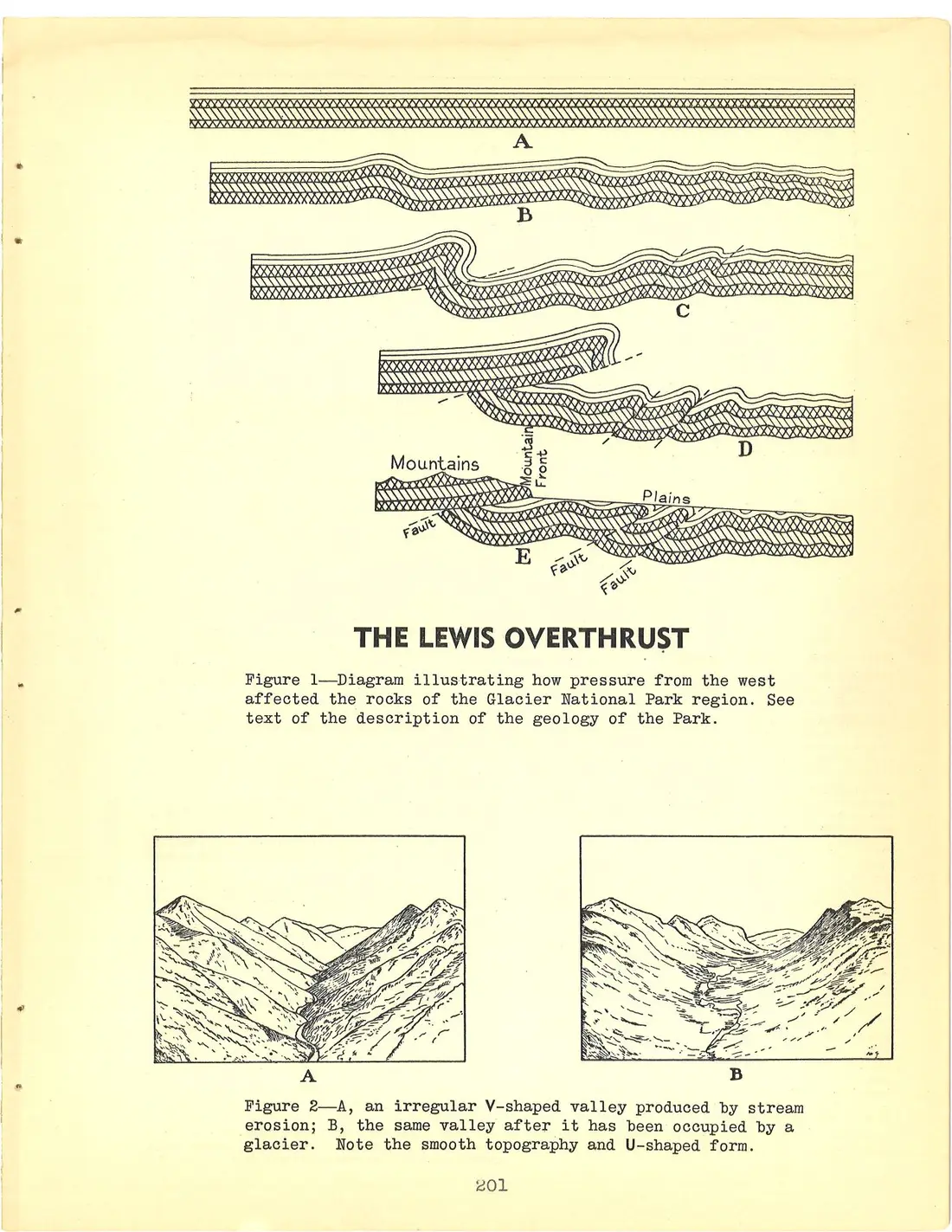
In late Cretaceous time, about 60 million years ago, the Rocky Mountain Revolution occurred, and sedimentary rocks which had been accumulating for many millions of years were slowly folded and faulted* by tremendous pressures within the earth to form the Rocky Mountains. These movements of the earth's crust were not, as is often popularly believed, sudden, but occurred intermittently over a very long period of time. The outstanding manifestation of this crustal deformation of the earth in the Glacier Park region was the Lewis overthrust. Figure 1, which illustrates this overthrust, and the following explanation are taken from pages 24-27 of Origin of the Scenic Features of the Glacier National Park by M. R. Campbell. Figure 1
"...represents the rock strata as they would have appeared in a deep east-west trench, provided the spectator could have watched long enough, possibly thousands of years, to have seen the movement take place. The spectator is supposed to be looking north, and in section A he sees the edges of the rock strata lying flat as they were originally deposited in bodies of water, some in the ocean and some in shallow lagoons and lakes.
"After the rocks were laid down in a horizontal position, great pressure was exerted from the west and what is now the mountain mass was crowded forward or eastward against the immovable rocks of the plains. As the force was resistless, there was no escape except by bending and wrinkling, and it is supposed that one large fold and several minor ones were produced, as shown in section B.
"The pressure, though relieved slightly by the corrugation, still persisted, and the folds were greatly enlarged, as shown in section C. At this stage the folds had nearly reached their breaking limit, and had the pressure continued the tendency would have been for the rock strata to break along the lines of least resistance, which is indicated in the various folds by broken lines. As time went on, the pressure continued and the strata broke in a number of places, as indicated in the diagram, and the rocks on the west side of the folds were pushed upward and over the rocks on the east, as shown in section D. What are now the mountain rocks are represented by patterns of cross lines; these rocks have been shoved over the plains rocks (represented in white), producing an overthrust fault.
"As the rocks at the west were thrust eastward and upward they
[Diagram: Five stacked geologic cross-sections labeled A through E, showing rock strata first lying flat (A), then folding under pressure from the west (B and C), breaking and thrusting over the plains rocks along dashed fault lines (D), and finally forming the present mountains (E). Section E is labeled "Mountains," "Mountain Front," and "Plains," with three fault lines each labeled "Fault."]
THE LEWIS OVERTHRUST
Figure 1—Diagram illustrating how pressure from the west affected the rocks of the Glacier National Park region. See text of the description of the geology of the Park.
[Diagram: Two framed landscape sketches side by side, labeled A and B. Sketch A shows a narrow, irregular V-shaped stream valley winding between rugged mountain ridges; sketch B shows the same valley broadened into a smooth U-shaped trough.]
Figure 2—A, an irregular V-shaped valley produced by stream erosion; B, the same valley after it has been occupied by a glacier. Note the smooth topography and U-shaped form.