Glossary of Geological Terms
made, in all probability, a mountain range, but they did not at any time project into the air as indicated in diagram D, because as soon as the rocky mass was uplifted above drainage level, streams began to wear it away and to cut deep canyons in its upland surface, and they also reduced the soft rocks of the plains to a nearly level surface. The rocks of the mountains, owing to their more resistant character, still tower above the plains, and where they overlie the soft rocks the mountains are terminated by a vertical wall of limestone (as shown in section E). This explains the absence of foothills, which is such a conspicuous feature of this mountain front and one in which it differs from most mountain ranges."
The exact amount of lateral movement involved in the Lewis overthrust is unknown. Measurements have been made of the distances up the eastern park valleys to which erosion has removed the Proterozoic cover for the younger plains rocks. How much farther than this the fault surface extends southwestward, under the mountain rocks, is not known. Dr. C. L. Fenton, after several summers of study in Glacier Park, concluded that the Lewis overthrust moved eastward, over the adjacent plains rocks, at least 30 miles.
Stream Erosion
If stream erosion had not been active during and after the slow overthrust fault movement, the product of the overthrust would have been a huge block-like mass, rising like a plateau above the surrounding country. The individual valleys and mountains of Glacier Park are not direct results of the fault movement, but of the stream erosion following that movement. Streams flowed vigorously down the steep margins of the overthrust mass, cutting steep valleys and steadily extending the heads of these valleys into the mass. In this manner the whole overthrust was dissected by a network of valleys. Mountains and ridges appeared as the residual masses remaining when the valleys were cut out around them.
These stream-cut valleys were not like those of Glacier today. The floors were narrow and the sides rose in the V-shape characteristic of young stream valleys. The mountains were broad-based, with relatively gentle slopes (see part 1 of figure 2). The valley heads ended in narrow ravines instead of broad cirques* and precipitous cliffs, and sharp horn-like peaks were absent.
Glaciation
The size and shape of the pre-glacial mountains and valleys of the Glacier Park region were profoundly altered by glaciation. It was probably early in the Pleistocene* Epoch, perhaps 1,000,000 years ago, that cooling climate caused snow to first persist all year long at the upper ends of the stream valleys. Winter accumulation of snow exceeded summer wasting and the snow banks grew in both size and depth. They eroded the rock beneath them, cutting basins (known as cirques) in the mountain sides. The snow near their bases was subjected to increasing pressure from above and recrystalized to form granular snow and, finally, solid ice. When the depths of these fields of snow and ice attained a critical magnitude, the pressure on the ice near the base forced it to move down slope. Thus were glaciers* born in the heads of all the valleys of the park.
As snow accumulation at the heads of the glaciers continued to exceed wasting (chiefly melting and evaporation), the glaciers grew, extending down the valleys and finally filling them.
"There is abundant evidence in the forms of the valleys and in the scratches left by the moving ice to prove that it (the ice) was at least 2,500 feet deep in the larger valleys and that the crests alone remained above its level. This, of course, means that immense glaciers must have originated in these mountains and flowed out in all directions, extending 20 or 30 miles onto the Great Plains on the east and down the valley of the Flathead River on the west."[1]
[1] M. R. Campbell, Origin of the Scenic Features of the Glacier National Park, p. 35.
These valley glaciers were in many respects similar to streams. They included a main trunk and tributaries; they drained the region of snow much as streams drain the water; they eroded, transported and deposited rock material.
Geologists believe that there were at least two separate periods of intensive glaciation in this region in the Ice Age.* That is, at least twice climate was such that large valley glaciers developed, as described above, and filled the valleys for long periods. Then, with climate change, wasting of the ice came to exceed accumulation, and the glaciers receded to the heads of the valleys and disappeared.
Thus, during the last million years, periods of intensive glaciation have alternated with interglacial periods in which stream erosion has been dominant. The periods of glaciation profoundly altered the topography of Glacier Park. Glacial erosion widened and deepened the valley floors, giving them their broad U-shaped profiles. It is responsible for the sharp peaks and divides, the broad cirques at the heads of the valleys, the hanging tributary valleys, most of the lakes, and many of the waterfalls. Glacial deposition of both outwash* and moraines* was common in the lower ends of our valleys and on the flat country, both east and west of the park. Much of the Cretaceous plains rock of the Blackfoot Indian Reservation is covered today with a mantle of these glacial deposits; they are evident in many road-cuts along the Blackfoot and Chief Mountain highways. For a more complete discussion of glacial erosion and deposition, the reader is referred to the article, "Glaciers and Glaciation in Glacier National Park," in this manual.
Today
With the recession of the glaciers to the heads of the valleys, streams have once more assumed the dominant role in erosion. If undisturbed, they will, in the centuries ahead, work slowly to eliminate such irregularities in their course as waterfalls, lakes, and rapids and to establish a smooth, gentle gradient. They will seek to alter or eliminate the broad U-shape of the valley floors, the cirques, the valley steps, and the hanging tributaries. Thus far the streams have accomplished little in this destruction of the products of the last great ice advance and the valleys of Glacier have retained strikingly their glaciated forms.
The line of the Lewis overthrust is apparent today all along the abrupt eastern margin of the mountains. Limestone cliffs at the foot of the mountains commonly mark the lowest formation of the Proterozoic* overthrust rocks, separated by the fault plane from the Cretaceous* plains rocks on which they rest. The fault line is now very irregular, as in the lower parts of their valleys the streams on the eastern side of the park have cut completely through the overthrust mass, exposing the younger plains rocks. The Lewis overthrust is probably the prize geologic exhibit of Glacier Park. "In other parts of the world, as great or greater overthrusts are known to geologists, but in no case is there one so extensive in which the observer can actually see the trace of the fault throughout the greater part of its length."[1]
[1] Campbell, Origin of the Scenic Features of the Glacier National Park, pp. 30, 31.
It is interesting to note that geologists believe that we may now be in an interglacial period of the Ice Age, with the climate becoming warmer and the ice receding. Perhaps in 200,000 years or so, as has happened several times in the past million years, the climate will become somewhat cooler, great ice sheets will invade the upper Mississippi Valley, and huge valley glaciers will cover all but the highest peaks of Glacier Park.
III. THE ROCKS
General
Marine sedimentary* rocks are dominant in Glacier Park. The mountain rocks are of Proterozoic age, having been formed on the bottoms of shallow inland seas at least 600 million years ago. The plains rocks, east of the line of the Lewis overthrust, are Cretaceous marine sediments. There are a few igneous* rocks present in the form of relatively thin intrusions* and lava flows. The masses of granite common to many mountains are entirely absent.
The Formations
The mountain rocks of Glacier Park, those making up the overthrust block, are commonly divided into four formations,* each from one thousand to several thousand feet thick. These lie one above the other in the order in which they were deposited. They are, from oldest to youngest and lowest to highest, Altyn Limestone, Appekunny Argillite, Grinnell Argillite, and Siyeh Limestone. Tilting and local faulting have distorted this series somewhat, but, in general, as one climbs from valley floors to the mountain heights, one passes through this series in order, from the oldest to the youngest.
Altyn Limestone. Limestone is the principal rock of the formation. It is the oldest rock in the park and forms the base of many of the mountains. It varies considerably in color, but is often gray, weathering to buff. It may be seen at the bases of many mountains, including Appekunny Mt., Divide Mt., and Mt. Wynn. It is quite hard and forms steep cliffs.
Appekunny Argillite. The dominant rock is argillite, a rock similar to shale but somewhat harder. Green and greenish-gray are the usual colors, though there are some white and dull red beds. Being the second oldest formation, it is commonly found just above the Altyn formation and, where the Altyn formation is not visible, often lies at the base of the mountains. It may be seen, for example, at the base of Grinnell Mt.
Grinnell Argillite. Like the Appekunny formation, it is chiefly argillite and is bright colored. The dominant color is red, though there are some white and light-green rocks. Where the younger rocks have been removed by weathering and erosion, the Grinnell formation is found at the tops of the mountains. The red summits of Mt. Rising Wolf and Red Eagle Mt. are examples.
Siyeh Formation (or Siyeh Limestone). Impure limestone is the dominant rock of the lower member* of this formation. It is generally dark gray, weathering to buff. Above the limestone are beds of greenish and reddish argillite. The Siyeh formation contains the youngest and hence, generally, uppermost rocks of the Lewis overthrust block. As such it forms the tops of many of the peaks and ridges along the crest of the Lewis Range. This formation includes the igneous rocks of the park. Igneous rock is limited to a sea-floor lava flow, now exposed near Swiftcurrent Pass, and to some small igneous intrusions*. The most striking of the latter is the diorite* intrustion, appearing as a horizontal black band on Mt. Gould and the Garden Wall. Long before the Lewis overthrust, molten lava forced its way between horizontal beds of sedimentary rock and hardened to form this layer of diorite, 40 to 120 feet thick. A thin layer of the limestone on each side of the intrusion was converted to white marble by the heat of the lava.
IV. SOME GEOLOGICAL OBSERVATIONS ALONG THE HIGHWAYS OF THE PARK
Only the most obvious and important items of geologic interest are discussed in this section. For more technical and detailed coverage, the driver is referred to the article "Geological Studies Along Park Highways," which will be found in editions of this manual of 1941 and earlier.
Glacier Park to Two Medicine
The highway runs north to Two Medicine Junction, paralleling the mountain front on the west. The Lewis fault line lies not at the very base of the mountains, but where the slope becomes steep. Thus, on Squaw Mt. it crosses a little below "the squaw." From Two Medicine Junction the road follows the north shore of Lower Two Medicine Lake. Below the lake the valley is filled with a stream deposit of sand and gravel which dammed the valley to form the lake. Glacial erosion may also have contributed to the lake basin. Today, a man-built dam somewhat increases the lake's size.
The fault line follows the base of Scenic Point, crosses the valley near Trick Falls and extends northward along the base of Spot Mt. Trick Falls is formed by a ledge of Altyn limestone, marking the base of the Lewis overthrust block. Most of the water of the falls flows through a subterranean tunnel in the limestone and is discharged from the mouth of the tunnel, less than half-way up the ledge. The high water of early summer conceals the tunnel mouth, as there is then considerable flow over the top of the ledge as well as through the tunnel.
From Trick Falls the highway ascends the ridge marking the margin of the overthrust. A mantle of glacial deposit reduces the gradient of the Altyn limestone ledge and hides the rock from view. Two Medicine Lake, soon in sight, is an example of a rock basin lake, the lake basin having been carved in an area of relatively weak rock by glacial erosion.
Though there are no glaciers remaining in Two Medicine Valley, the broad valley floor, the rock basin lakes, the steep mountain sides, and the cirques which form the heads of the tributary valleys all speak of past periods of vigorous glaciation.
Glacier Park to St. Mary Junction
In ascending Looking-Glass Hill (Two Medicine Ridge), the broad U-shape of the Two Medicine Valley floor is strikingly apparent. The valley was obviously shaped by a large glacier.
"The great Two Medicine glacier...extended far out over the plains nearly 40 miles east of the mountain front, with a maximum width of 20 miles where crossed by the Park-to-Park Highway (U.S. No. 89) southeast of Browning. The higher parts of the Two Medicine Ridge were not overridden by several hundred feet by this great piedmont glacier, but 8 miles southwest of Browning, where the ridge is lower, the ice spread north to the valley of Cutbank Creek...."[1]
[1] William C. Alden, "Geological Studies Along Park Highways," Glacier Park Transport Co. Driver's Manual (1941 ed.), pp. 213-236.
On the south side of Looking-Glass Hill the road cuts reveal glacial deposits of both till* and outwash*, which cover much of this slope. From the top of the hill the abrupt rise of the mountains of Glacier Park from the low rolling plains to the east is strikingly apparent. One can look along the line of the Lewis fault as far as Divide Mountain. As the road descends the north side of the hill, road cuts reveal beds of Cretaceous shale, at some points spectacularly deformed by local folding and faulting. This deformation of the relatively young rocks overlying the plains probably occurred at the time of the Lewis overthrust, as a result of the crustal pressures associated with that great fault.
From the foot of Looking-Glass Hill, the highway winds across Cut Bank Ridge and down into the broad mouth of Cut Bank Valley.
"As on the Two Medicine Ridge, so also the highest parts of the Cutbank and Milk River Ridges, which are capped with early Pleistocene glacial drift*, were not overridden by the ice at the last, or Wisconsin, stage of glaciation. The ice of the great Cutbank glacier was, however, 700 to 1,000 feet thick as far east of the mountain front as the highway (U.S. No. 89)...."[2]
[2] Alden, op. cit., p. 216.
The Lewis fault line lies near the bottom of the steep basal slopes of the mountains on both sides of the valley, crossing the creek at the base of Kupunkamint (or Amphitheater) Mt. There are no large lakes in Cutbank Valley, but several small ones lie near the head.
From Cutbank Valley the highway climbs over the Hudson Bay Divide, at a point just east of Divide Mountain. This impressive peak, like Chief Mountain to the north, is an example of a "mountain without roots." It consists, like the other mountains, of overthrust Proterozoic rocks (Altyn limestone with a cap of Appekunny argillite) on a base of younger plains rocks. However, in this case, erosion has cut through the Proterozoic rocks in the valley between Divide and White Calf Mountains, exposing the underlying plains rock. Thus, Divide Mountain is an "island" surrounded by younger rock.
St. Mary Junction to Lake McDonald
The St. Mary Valley is one of the largest valleys of the park. Its steep sides and curved floor speak of glaciation. In the lower end of the valley where the rocks are soft, the glacier cut a broad valley floor, while above The Narrows, where the rocks are more resistant, the valley remained relatively narrow. The two St. Mary Lakes are not believed to be the immediate results of glaciation. M. R. Campbell, who made a geologic study of the park area, states:
"This valley was doubtless at one time occupied only by a stream that meandered over the rocky bottom, which had been smoothed and scoured by the ice of the great glacier. Into this valley Swiftcurrent Creek poured a large amount of sand and gravel, building up a huge delta that finally extended entirely across the valley, effectively ponding the waters above. Thus a lake 16 miles long was produced; but other streams were at work carrying sand and gravel into the valley, and Divide Creek on the south and Wild Creek on the north also built out deltas which finally coalesced, separating the body of water into the two lakes that exist today."[1]
[1] Campbell, The Glacier National Park: A Popular Guide to Its Geology and Scenery, p. 23.
Thus Upper and Lower St. Mary Lakes are separated by a deposit of stream delta material.
The mountains bordering the St. Mary Valley include some of the highest in the park. Mt. Jackson and Mt. Siyeh are both over 10,000 feet high. Little Chief and Going-to-the Sun Mountains both rise sharply from the upper lake to heights more than 5,000 feet above it.
A number of prominent glacial cirques may be noted. Those heading the valleys on both sides of Fusillade Mt. are especially prominent from the highway. The sharp profile of this mountain is a result of the glacial enlargement of these cirques, which cut into the mountain from both north and south.
The Lewis fault line follows the base of Red Eagle Mt., crosses the lake at The Narrows and extends north along the base of the steep slopes of Whitefish and Flattop Mountains.
Following the highway up St. Mary Valley, one has a splendid opportunity to distinguish the four formations making up the Lewis overthrust rock. The original sequence of rocks is remarkably undisturbed and as one ascends the valley, one observes in the road cuts progressively younger rocks. From The Narrows, where the Altyn limestone, weathered to a light buff, is seen beside the road, one climbs through the layer of Appekunny argillite (dominantly green, but some red beds), the layer of Grinnell argillite (dominantly maroon, argillite, but some light-colored quartzite), and finally into the lower limestone member of the Siyeh formation. This limestone, gray weathered to buff, is the rock exposed at Logan Pass. The sheerness of its walls necessitated the extensive blasting and sometimes tunneling of the roadbed on both sides of the pass. The argillitic (reddish and greenish) upper members of the Siyeh formation, the youngest of our present mountain rocks, may be observed, above the limestone, on the high peaks—Mt. Clements, Piegan Mt., Mt. Pollock, etc.
Less than a mile east of Logan Pass, a little above the tunnel, the highway crosses a dark-colored igneous intrusion* of diorite*, similar in nature to the black bands which show so strikingly on some of the park mountains. This intrusion, about 100 feet thick, dropping from the heights of Piegan and Pollock Mountains down to the south across the road and thence southward, may be seen interbedded with limestone in the upper part of the cliff below the Hanging Gardens.
"All the way, about 7 miles from Logan Pass northward down to the switchback about 4,500 feet above sea-level, the road is graded along the steep slope on the Siyeh limestone. Near the switchback there are cuts in maroon and green argillite in the upper part of this formation. A short distance south of and both above and below the switchback, there are fine examples of concentric algae growths (Cryptozoan) and also some ledges along the road are finely glaciated as a result of abrasion by the southward-moving ice of the ancient McDonald Creek glacier. This glacier, at its maximum, advanced far down the valley (about 35 miles), traversed the lake basin, and extended past the site of Belton and through the Bad Rock Canyon, beyond which it joined a great glacier in the Flathead Valley."[1]
[1] Alden, "Geological Studies Along Park Highways," Drivers' Manual (1941), pp. 215, 220.
The algal reefs mentioned above are of considerable interest. They are composed of the shell-like secretions of colonies of one-celled plants which grew on the bottom of the Proterozoic sea. As such they are among the oldest fossils in existence. In describing the algal reefs, Dr. C. L. Fenton states: "A transmountain highway has cut two reefs, whose perfection fits them for textbooks. They show the low central core, or ridge, composed of conical colonies whose weight squeezed and compressed the soft mud on which they grew."[1]
[1] Fenton, "Sea Floors of Glacier National Park," The Scientific Monthly, Sept., 1939, p. 225.
"To the geologist this was far more than a piece of rock. It was the fossil remains of a colony of algae—simple, green or brownish plants, that lived there when the present Rocky Mountains were the site of a shallow sea. Surrounding its delicate fibers with lime, the colony remained while the muds of the sea floor hardened into stone...."[2]
[2] Fenton, "Algae of Antiquity," Nature Magazine, July 1934, pp. 15, 16.
As the highway descends the McDonald valley from the switchback, Grinnell argillite and later Appekunny argillite will be observed in the road cuts. Logan and McDonald Falls flow over ledges of the latter.
The McDonald Valley, though narrow, shows the U-shape common to the glaciated valleys of the park. Lake McDonald, the largest lake in the park, is probably a product of both glacial erosion which carved a basin, and of damming by glacial deposition in the lower end of the valley. A number of cirques can be observed in the region, the most prominent being that occupied by Avalanche Lake. Above this lake lies Sperry glacier, whose meltwater cascades over the steep cirque walls into the lake below.
Babb, Montana, to Waterton, Alberta
The highway, on leaving Babb, runs north to Kennedy Creek and then turns northwest toward Chief Mountain. The region traversed is largely covered with a layer of glacial deposit. This is apparent from the unsorted gravel seen in the road cuts.
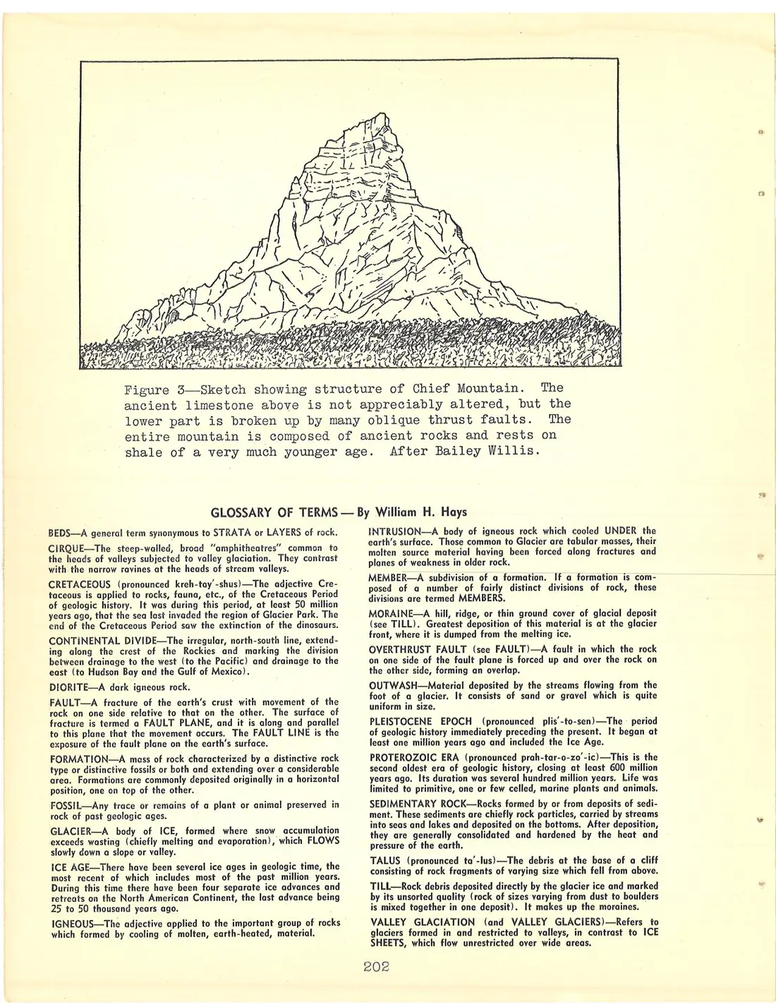
Chief Mountain, for which the highway was named, is especially prominent because it lies isolated on the plains east of the main mountain front. It is not one of the park's highest mountains, but its prominent position, its awe-inspiring east face, and its unique geology have made it the most widely known topographic feature of the Montana Rockies. Like Divide Mountain, discussed above, it consists of an isolated mass of Proterozoic rock, resting on a base of relatively young plains rock. Chief Mt. was once joined with Gable Mt., behind it, as part of the Lewis overthrust; but erosion has removed all the overthrust rock around Chief Mt., leaving it an "island" surrounded and underlain by much younger plains rocks. The Lewis overthrust fault line lies at the base of the mountain (see figure 3), at about 7,000 feet. The sheer mountain walls rise more than 1,500 feet to an elevation of 9,056. The mountain is composed entirely of hard Altyn limestone. For more than two-thirds of the mountain's height—up to the prominent ledge on the east face—the beds* of limestone are not horizontal, but are considerably crumpled and faulted, the rock having piled up on itself to its present height. The upper 600 feet of the peak consists of almost horizontal, relatively undistorted beds.
As the highway continues northward it crosses the foot of the Belly River Valley and finally descends to the broad glaciated floor and beautiful lakes of the Waterton Valley. W. C. Alden believes that the deposition of Blakiston Brook is, to a large extent, responsible for the presence of the Waterton lakes. He states that "the brook has extended a great fan of alluvial gravel south to east to northeast, shoving the river eastward and nearly blocking the broad valley. By so doing, it impounded the waters forming Waterton Lake. It was assisted in obstructing the valley by Sofa Creek, which built a similar alluvial fan or cone on the east side of the Valley."[1] Probably glacial erosion was also important in forming the lake basins. The Prince of Wales Hotel rests on a hill composed of glacial deposit which may represent moraine deposited by the Waterton Glacier during its recession.
[1] Alden, "Geological Studies Along Park Highways," Drivers' Manual (1941), p. 225.
St. Mary Junction to Many Glacier Hotel
From St. Mary Junction the highway follows the east shore of Lower St. Mary Lake which, though large, is generally shallow when compared with the lake above it. The flat area between the bridge at the lake's outlet and Babb Junction is underlain by more than 100 feet of gravel and sand deposited by Swiftcurrent Creek. It is this deposit, built out by the creek from the west, which is believed to have dammed the valley and caused the St. Mary lakes.
Leaving Babb, the highway enters the lower end of Swiftcurrent Valley. At several points road cuts reveal the black Cretaceous* shale (one of the relatively young plains rocks) which, together with glacial deposit, composes Swiftcurrent Ridge. This shale is a weak rock, subject to landsliding and slow downslope creep, and is responsible for occasional obstruction of the highway and for actual slow movement of parts of the highway downslope near Sherburne Lake.
The outstanding geologic feature of Swiftcurrent Valley is the excellent exposure of the Lewis overthrust fault on both sides of the valley below the head of Sherburne Lake. The ridges underlying the overthrust are composed of Cretaceous plains rocks. The lower Altyn limestone bed of the overthrust block is marked by steep cliffs which form the bases of the mountains on both sides of the valley, contrasting with the gentle slopes of the ridges below them. The exact line of fault contact, lying near the foot of the cliffs, is generally partially obscured by talus*. The fault line follows the base of the cliffs on the north side of Mt. Wynn and Mt. Allen, crosses the valley at the head of Sherburne Lake and extends northeast along the base of the cliffs of Appekunny Mt.
Altyn limestone, the lowest formation of the overthrust, is exposed on the valley floor in the area between Sherburne and Swiftcurrent Lakes. Many Glacier Hotel is built on this rock. The lower slopes around Swiftcurrent Lake consist of greenish Appekunny argillite. Above it are the red beds of the Grinnell argillite which form the top of Altyn Mt.. The higher peaks, such as Grinnell, Wilbur and Gould are capped with part of the Siyeh formation, the same rock which is found at Logan Pass. Between two beds in this formation a black band representing a diorite* igneous intrusion*, crosses the face of Mt.Gould, extends under Grinnel glacier and reappears on Mt. Grinnell. This same intrustion may be noted in other valleys of the park.
The Swiftcurrent Valley was profoundly altered by glaciation. Products of glacial erosion include the broad U-shape of the valley floor, the many cirques, and the chain of lakes. The cirque at the head of Cracker Canyon accommodates Cracker Lake, the cirque wall on Mt. Siyeh rising 4,000 feet above the lake. Grinnell Glacier, the largest body of ice in the valley, lies in a small cirque in the wall of the large major cirque, which holds Grinnell Lake. The cirque holding Iceberg Lake is also very spectacular, the cirque walls almost encircling the lake. A good example of a rock basin lake is Swiftcurrent Lake, whose basin was cut into an area of relatively weak rock by glacial erosion. A line of resistant Altyn limestone forms its outlet.
[Diagram: Line sketch of Chief Mountain, a rugged pyramid-shaped peak with layered and fractured rock faces rising above a brush-covered talus slope at its base.]
Figure 3—Sketch showing structure of Chief Mountain. The ancient limestone above is not appreciably altered, but the lower part is broken up by many oblique thrust faults. The entire mountain is composed of ancient rocks and rests on shale of a very much younger age. After Bailey Willis.
GLOSSARY OF TERMS — By William H. Hays
BEDS—A general term synonymous to STRATA or LAYERS of rock.
CIRQUE—The steep-walled, broad "amphitheatres" common to the heads of valleys subjected to valley glaciation. They contrast with the narrow ravines at the heads of stream valleys.
CRETACEOUS (pronounced kreh-tay'-shus)—The adjective Cretaceous is applied to rocks, fauna, etc., of the Cretaceous Period of geologic history. It was during this period, at least 50 million years ago, that the sea last invaded the region of Glacier Park. The end of the Cretaceous Period saw the extinction of the dinosaurs.
CONTINENTAL DIVIDE—The irregular, north-south line, extending along the crest of the Rockies and marking the division between drainage to the west (to the Pacific) and drainage to the east (to Hudson Bay and the Gulf of Mexico).
DIORITE—A dark igneous rock.
FAULT—A fracture of the earth's crust with movement of the rock on one side relative to that on the other. The surface of fracture is termed a FAULT PLANE, and it is along and parallel to this plane that the movement occurs. The FAULT LINE is the exposure of the fault plane on the earth's surface.
FORMATION—A mass of rock characterized by a distinctive rock type or distinctive fossils or both and extending over a considerable area. Formations are commonly deposited originally in a horizontal position, one on top of the other.
FOSSIL—Any trace or remains of a plant or animal preserved in rock of past geologic ages.
GLACIER—A body of ICE, formed where snow accumulation exceeds wasting (chiefly melting and evaporation), which FLOWS slowly down a slope or valley.
ICE AGE—There have been several ice ages in geologic time, the most recent of which includes most of the past million years. During this time there have been four separate ice advances and retreats on the North American Continent, the last advance being 25 to 50 thousand years ago.
IGNEOUS—The adjective applied to the important group of rocks which formed by cooling of molten, earth-heated, material.
INTRUSION—A body of igneous rock which cooled UNDER the earth's surface. Those common to Glacier are tabular masses, their molten source material having been forced along fractures and planes of weakness in older rock.
MEMBER—A subdivision of a formation. If a formation is composed of a number of fairly distinct divisions of rock, these divisions are termed MEMBERS.
MORAINE—A hill, ridge, or thin ground cover of glacial deposit (see TILL). Greatest deposition of this material is at the glacier front, where it is dumped from the melting ice.
OVERTHRUST FAULT (see FAULT)—A fault in which the rock on one side of the fault plane is forced up and over the rock on the other side, forming an overlap.
OUTWASH—Material deposited by the streams flowing from the foot of a glacier. It consists of sand or gravel which is quite uniform in size.
PLEISTOCENE EPOCH (pronounced plis'-to-sen)—The period of geologic history immediately preceding the present. It began at least one million years ago and included the Ice Age.
PROTEROZOIC ERA (pronounced prah-tar-o-zo'-ic)—This is the second oldest era of geologic history, closing at least 600 million years ago. Its duration was several hundred million years. Life was limited to primitive, one or few celled, marine plants and animals.
SEDIMENTARY ROCK—Rocks formed by or from deposits of sediment. These sediments are chiefly rock particles, carried by streams into seas and lakes and deposited on the bottoms. After deposition, they are generally consolidated and hardened by the heat and pressure of the earth.
TALUS (pronounced ta'-lus)—The debris at the base of a cliff consisting of rock fragments of varying size which fell from above.
TILL—Rock debris deposited directly by the glacier ice and marked by its unsorted quality (rock of sizes varying from dust to boulders is mixed together in one deposit). It makes up the moraines.
VALLEY GLACIATION (and VALLEY GLACIERS)—Refers to glaciers formed in and restricted to valleys, in contrast to ICE SHEETS, which flow unrestricted over wide areas.